Image: Korea Meteorological Administration ()
Typhoon Khanun, the 6th typhoon of the year, is forecasted to make landfall in the eastern sea of Busan.
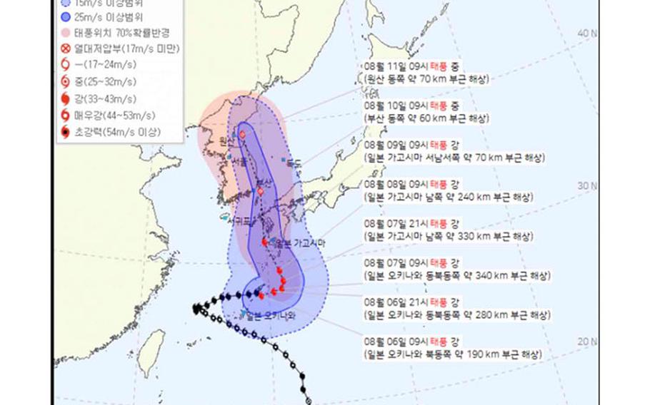
The Korea Meteorological Administration predicts that it will occur approximately 60 km east of Busan on the morning of the 10th. The typhoon’s intensity upon landing is expected to be ‘medium,’ with a central initial velocity ranging from 25 to 32 m/s.
The impact of the typhoon is expected to affect various regions: the Busan, Ulsan, and Gyeongnam areas from the night of the 9th to the night of the 10th, the Daegu, Gyeongbuk, and Chungbuk areas from the morning of the 10th to the morning of the 11th, and the Gangwon-do and eastern Gyeonggi areas from the morning of the 10th to the afternoon of the 11th.
There is a possibility of issuing a special typhoon warning for the affected regions.
Areas close to the landing point, such as Busan and Ulsan, are expected to experience winds of 25 m/s or more within the storm radius. The Gyeongnam area may encounter strong winds with speeds of 15 m/s or more.
The path of the typhoon appears to be closer to Korea than previously predicted, as it has shifted more westward compared to earlier projections.
The Korea Meteorological Administration emphasizes that the typhoon’s path might continue to change, given the discrepancy of 500 km between current numerical models’ landing points from east to west.